
There’s an old proverb that says “God looks out for fools, children and drunkards”. If that’s so, then we had Someone looking out for us three fools. After all, we set out on a completely unplanned, 3 day hike to the bottom of the Grand Canyon. During a blizzard.
The Grand Canyon is one of those special places that should be seen sometime in your life. And I don’t just mean standing on the edge and looking down. That’s how over 95% of visitors to this amazing natural wonder see the Canyon. Get out of your car, put on your boots, and get below the rim. You will be amply rewarded. And if you spend a night or more below the rim, you become a member of the 1% club. Just imagine, only about one percent of visitors hike and camp in the canyon every year!

My friends Ric and Steven and I set out on an epic road trip to the Grand Canyon and Death Valley on a cold February day, all the way from Vancouver, British Columbia. That full trip is the subject of a future post, so keep your eyes peeled for that. In this post, I’m focusing on our hike down the South Kaibab Trail to the Bright Angel Campground.
We reached the South Rim of the Canyon on a cool afternoon at the beginning of March and set up camp at Mather Campground. This large campground is in Grand Canyon Village about 4 miles from the South Entrance of the Park. With 327 campsites, Mather feels endless. But at this time of the year, the campground was maybe 20% occupied.
The Backcountry Office
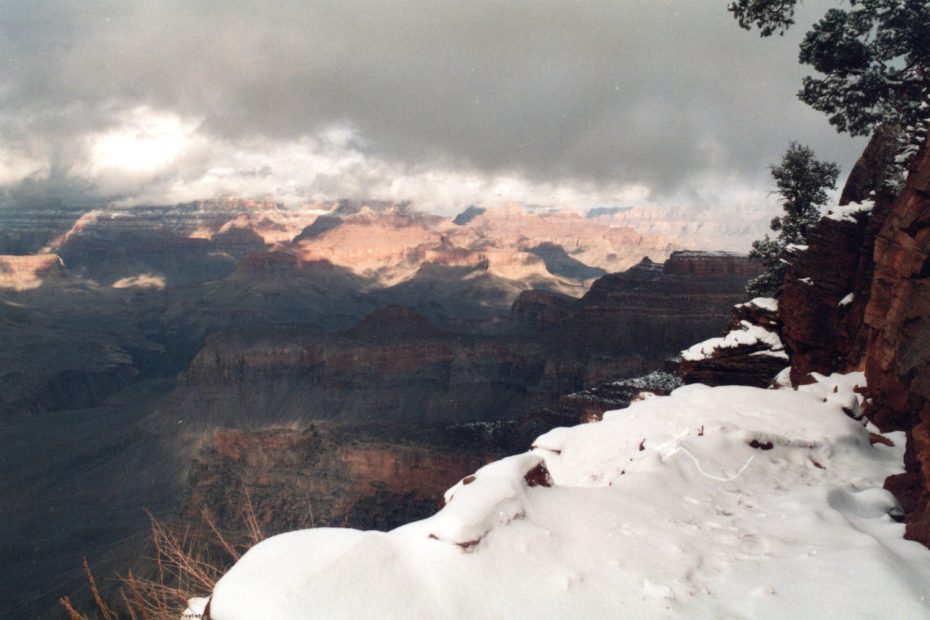
We spent our first day exploring the village, buying groceries and checking out the Canyon rim. My first view of the Grand Canyon was jaw-dropping. I cannot put into words what that first view was like. But I’ll try anyway. After all, no one wants to read “We looked at the canyon. It was cool.” But it was cool! It might have been the coolest thing I had ever set eyes on. For mile after mile, waves of fantastically coloured rock walls, towering fins, and heart-stopping chasms filled my vision. Before such an awesome spectacle, words fail. JW Powell, the first white explorer of the Grand Canyon put it best;
The wonders of the Grand Canyon cannot be adequately represented in symbols of speech, nor by speech itself. The resources of the graphic art are taxed beyond their powers in attempting to portray its features. Language and illustration combined must fail.
John Wesley Powell
Ultimately, standing before this spectacular vista, we were overcome with an overwhelming desire. We had to go into the Canyon! At any cost! Remember that bit previously about the three fools? Straightaway those fools headed over to the Backcountry Information Center to inquire about camping down in the Canyon.
The Backcountry information Center is an amazing place that has tons of information for anyone planning an extended hike into the Canyon. With mural-sized photos and lots of signs, the folks here will do everything in their power to convince you not to go! For example we viewed full color images of people lying on rocks at the bottoms of cliffs, covered in blood, and other people on hands and knees puking their guts out. Very enlightening! We ignored them all and filled out the necessary forms.
Hiking The South Kaibab Trail-A Simple Plan
The plan was simple; hiking the South Kaibab Trail down to the Colorado River and Bright Angel Campground and camping overnight. On Day Two start up the Bright Angel Trail and camp at Indian Gardens for our second night. And finally, Day Three, hike back up to the rim, thus completing our epic journey. What could be easier? Oh sure, we could take a mule ride to the bottom, stay at Phantom Ranch and eat steaks washed down with a nice, expensive wine. But where is the adventure in that? Actually we didn’t have enough money to do that, so no, it would have to be by our own two feet.
We headed back to our campsite with our backcountry permit, excited for the morning to come. Dinner cooked, dishes washed, we got busy prepping. Our backpacks full and ready, we climbed into our sleeping bags for a good night’s sleep.
We awoke early the next morning to 8 fresh inches of snow on the ground, and it was still falling! Ric convinced us to pack up and head to the trailhead. Once there we would assess and decide if our hike was a go. If it was still snowing, we’d head out of Arizona and make our way to Death Valley. It didn’t look good. The trunk of the car filled up with snow as we loaded our gear. The snow fell thickly, with no sign of stopping.

The Fools Choice
After a quick stop at the market to pick up a few snacks, we arrived at the trailhead. Surprisingly, the snow let up. We walked over to the start of the trail and looked out. A solid blanket of clouds completely obscured the Canyon. The snow lay thick on the trail. A lone set of footprints led down the trail and disappeared at the first bend. Hey look! Someone else decided to go, regardless of a little snow. And just like that, the snow stopped falling!
The information board at the trailhead had the weather report posted. The temperature here at the rim was a chilly 30 degrees, but at Phantom Ranch next to the Colorado River, it was a pleasant 72. A quick conference between the three of us confirmed our choice. Let’s do it! And so we returned to the car to retrieve our backpacks and prepare to set out.

For the first mile or so, we slogged through ankle deep snow, trying to walk in the prints left ahead of us. And gradually, the snow thinned. The steep trail tightly switch-backed, one after another. I was surprised just how steep it was. Less than an hour down the trail and we were walking in wet red soil. The snow was behind us. And suddenly the Canyon came into view as the sun came out. Once we reached Cedar Ridge the clouds began to quickly break up.
Hiking The South Kaibab Trail
Here and there, rocky promontories peered from the clouds. And in no time, the entire Canyon lay before and below us. We were hiking below the Canyon rim! We were in the Grand Canyon, hiking the South Kaibab Trail!
The South Kaibab Trail was built initially as an alternative to the Bright Angel Trail. An entrepreneur named Ralph Cameron had created the Bright Angel Trail around 1903, as a means to provide visitors access to his tourist camp near what is now Indian Gardens. He charged a toll to use the trail, which created a lot of controversy. As a result, two other trails were built; the Hermit Trail and the South Kaibab Trail.
There are a couple of big differences between Bright Angel and South Kaibab. The biggest is exposure. Bright Angel has many areas providing shade from the intense sun. South Kaibab is without shade for virtually its entire 7 mile length. The other big difference is the grade.

While Bright Angel meanders along faults and curves in the canyon, winding its way down to Indian Gardens and then the Colorado River itself, South Kaibab makes a steep beeline to the river. Bright Angel is two and a half miles longer. So for anyone thinking of doing the loop down to the river and back, I highly recommend going down the South Kaibab Trail and up the Bright Angel Trail! You’ll thank me.
Hockey Knees Are A Handicap
Even though it’s considered best practice following my above recommendation, that doesn’t make this trip easy. Far from it! If you have never experienced going down a steep hill for seven miles with very few level sections, you’re in for a treat. And when I say treat, I mean “Oh My God I Want To Die!”
Hiking the South Kaibab Trail means a constant jarring on knees, and my knees were feeling it. Having spent several years as a hockey goaltender, my knees were already pretty beaten up. But this punishment was brutal. By the halfway mark of the trail, I thought I was done. Not only that, but I was pretty sure that one of my companions was adding rocks to my pack whenever I wasn’t looking. Devious bastards!

At first, it was nice to stop and have a water break, take a few pictures and just look around. But as the hike wore on, I took fewer and fewer breaks. I found it too difficult to start up again after stopping for a few minutes. My knees were in such pain that it was easier to continue on at a slower pace without stopping. Because of this, Ric and Steven began getting further ahead with each switchback. Periodically they would stop and wait for me. I would pass them without looking up. “Take a break, Mike,” they would call to me. “Can’t stop.” I told them. “I won’t be able to start again.” Hiking the South Kaibab Trail was becoming my own personal Hell.
The Black Bridge and the Campground
The Day was growing late and the sun had disappeared behind the Canyon rim. My zombie walk down the trail hadn’t helped us get down any faster. We were going to get into Bright Angel Campground a little later than planned.
At last we came to a turn in the trail, and the Colorado River appeared below us. We could see the black bridge that crossed the river and the last half mile or so to Bright Angel Campground. Several more switchbacks and a short tunnel brought us to the bridge, then across the river. Unfortunately I have no memory of crossing the bridge, going through the tunnel, or walking the last bit into the campground. The pain from my knees and thighs was so intense I was in a trance.
Ric and Steven put up their tents, and then did mine. I was incapable of doing anything. Ric made some dinner and brought it to me. I curled up in my sleeping bag and soon drifted into unconsciousness, absolutely certain that I would need to be flown out of the Canyon by the Park Rangers. There was zero chance of me walking out out on my own. Hiking the South Kaibab Trail had done me in.

The morning brought sunshine and hot coffee. I crawled late from my sleeping bag and stood up. Yes, I stood up! Without crutches or a walker. I took a few tentative steps to test my knees. I could walk around without too much pain. Maybe I could hike out without the use of a helicopter?
Back Across The Colorado
We spent part of the morning exploring around Bright Angel Creek and Phantom Ranch. After our hike down with no other people or facilities of any kid, Phantom Ranch seemed so civilized. There was a group of tourists getting ready to ride mules back up to the top of the Canyon. Cowboys wearing dusty, worn chaps were packing the mules while the tourists stood about, drinking coffee. I wondered about getting on a mule to come down the trail to Phantom Ranch. I don’t think I could do it. The mule has all the control. What if my mule decided he couldn’t go on anymore, or wasn’t paying attention to that 500 foot drop-off? No, I’ll trust my own two feet, thank you!
It was time for us to head over the river and meet up with the Bright Angel Trail. My knees seemed to be functioning with minimal pain, so there would be no helicopter ride for me this day. I picked up my pack and threw it over my shoulders. Yow! I wasn’t expecting the pain to come from my shoulders! I guess carrying 30 pounds of gear on a steep downhill trail was a punishment I hadn’t noticed, owing to the excruciating pain that had emanated from my knees the day before. But with the pack in place on my back, and the waist belt tightened, my shoulders didn’t hurt too badly. This I could manage.

My first tentative steps from the campsite gave me hope. I wasn’t experiencing much pain. In fact, as we walked up to the Silver Bridge to cross the Colorado River, the pain almost completely disappeared. But then we passed over the high point of the bridge and started down the slight slope to the other side, and my knees screamed at me. Needless to say, on the hike up Bright Angel, every time the trail took a dip downwards, I would swoon from the pain. Those brief sections felt like I was back hiking the South Kaibab Trail, heading constantly downhill, pounding my knees to a pulp. Luckily there was soon very little downhill trekking. For the next two days we were climbing a vertical mile.
The sun was shining, the air was warm, and the weather forecast looked great for the next few days. And despite our lack of preparation and experience, and my knees, we had conquered the South Kaibab Trail. That trial was behind us, and a new adventure was beginning. I was feeling pretty good about we three being part of the one percenters who hike down into the Grand Canyon every year, leaving behind the vast majority of tourists on the Canyon Rim. You could even say I was feeling a bit cocky. Considering we still had almost 10 miles of uphill hiking ahead of us over the next two days, I should have known better!
But that story is for the next post. Consider it Part 2 of the Epic Journey of The Three Fools. Stay tuned!
[…] the Grand Canyon, Beth-Rose was pretty adamant that she wanted to hike to the bottom of the canyon. Having done it waaay back in early 1990, I was somewhat reluctant. Been there, done that, got the tee shirt. Besides, that 3 day hike down […]
[…] Often near the end of winter, I’d get an itch to get in my car and head for warmer climes. Tired of the rain and cold, I yearned for the desert warmth and beauty. Many times I’ve driven south, to Death Valley, to Joshua Tree, or to the Grand Canyon. […]
[…] If you haven’t yet read Part 1, you can link to it here. […]